
Looking for an easy walk that takes you away from crowds, rewards you with great views, and can be done in a hour or less? On the Outer Cape, nothing beats a stroll to the summit of Truro’s Bearberry Hill, followed by a visit to the historic Bog House.
Bearberry Hill, named for the iconic ground cover that blankets parts of the Outer Cape, overlooks popular Ballston Beach and the marshy headwaters of the Pamet River. From the hill’s summit, fine views of the Atlantic and the Truro Hills abound.
The Bog House, beside a cranberry bog, is an 1830s building lovingly restored by the Friends of Cape Cod National Seashore.
From the parking area, go north about 75 feet, cross North Pamet Road, and turn left on the Bearberry Hill Trail, unsigned. Follow the trail gently uphill through a pine–oak forest to a fork, signed for the east and west summits of Bearberry Hill and also for the Bog House. Turn right on a sandy trail to gain the east summit. Blasts of wind from the ocean ensure that only the hardiest plants—stunted forms of pitch pine, black cherry, and bayberry—cling to the hillside.
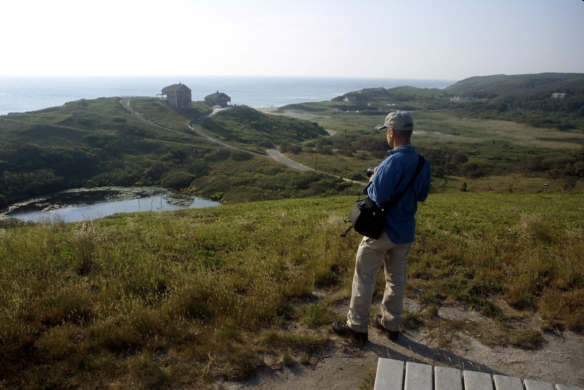
View southeast from east summit of Bearberry Hill. Photo (c) 2020 David Weintraub.
Bearberry, also called hog cranberry because of its unpalatable red berries, is a dwarf evergreen shrub and member of the heath family. Other heath-family members found along this route include black huckleberry, highbush blueberry, and cranberry. Pitch pine, black oak, scrub oak, black cherry, beach plum, arrowwood, and bayberry grow beside the trail, as do asters and goldenrods.
Truro’s Pamet River gets its start in a marshy area just south of Bearberry Hill. On Oct. 31, 1991, waves spawned by the combination of Hurricane Grace and a nor’easter (dubbed the “Perfect Storm”) blasted a 100-foot hole in the dune behind nearby Ballston Beach, temporarily creating an island out of most of Truro and all of Provincetown.
Now retrace your route to the previous junction and turn right. Go about 75 feet to the next junction: from here, the west summit is straight, and the Bog House Trail is right.
Walk straight about 150 feet on a sandy trail to the summit platform, which affords a fine view of the Bog House, a cranberry bog, and a large pond fringed with shrubs. After enjoying the view, return to the previous junction and turn left on the gravel Bog House Trail.
Wind downhill on a moderate grade, aided in places by steps. After the trail levels, curve right and climb to a T-junction with a sandy path, at about 0.5 miles. Turn left and in about 0.25 miles reach a junction, in a beautiful scrubby bowl, with the Bog House Trail.
American goldfinches, chipping sparrows, black-capped chickadees, tree swallows, gray catbirds, northern flickers, eastern kingbirds, and blue jays, prairie warblers, eastern towhees are some of birds you may see and hear from the trail. During summer, the scrubby areas here are favored by butterflies and dragonflies.
After looking and listening for birds, and perhaps spotting another winged creature, turn left on a sandy single-track trail and cross an open area dotted with wind-pruned trees. As you travel farther from the ocean, the effect of the wind lessens, and the tree cover thickens.
Where an unsigned trail goes straight, angle left and follow a rolling course through an area dense with trees and shrubs. A step-aided descent soon brings you to the Bog House, about 1.1 miles. A nearby information panel, beside the bog, describes the ecology of the wild cranberry and its traditional use by Native Americans and the Pilgrims.
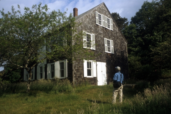
The Bog House. Photo (c) 2020 David Weintraub.
From here, walk southwest between the house and the bog to find a grassy dirt road. Follow it about 100 yards to North Pamet Road; then turn left and walk along the road’s left side (facing traffic) for about 0.4 miles to close the loop. Carefully cross North Pamet Road and retrace your route to the parking area.
Directions to the parking area
From Route 6 northbound in Truro, take the Pamet Roads–Truro Center exit. After about 100 feet, turn left on North Pamet Road. Go 1.5 miles; then turn right on a driveway that is just past a roadside parking area and just before a youth hostel. Now turn immediately right into a small parking area. From 9 a.m. to 6 p.m., parking here is limited to 2 hours. The trailhead is on the northwest side of the parking area, beside a CCNS information board.
From Route 6 southbound in Truro, take the Pamet Roads–Truro Center exit. Bear right and go 0.1 mile to an intersection signed for Pamet Roads, Route 6, and Provincetown. Turn right, go under Route 6, and at the next intersection turn left on North Pamet Road. After several hundred feet, the exit from Route 6 northbound joins on the left. From there, follow directions above.
David Weintraub is a writer, editor, and photographer based in Cape Cod and South Carolina. He is the author of eight guidebooks, including Walking the Cape and Islands and Adventure Kayaking: Cape Cod and Martha’s Vineyard.
